|
imran
|
 |
« on: December 22, 2015, 05:33:51 AM » |
|
1. Blue Marble, 2012 A ‘Blue Marble’ image of the Earth taken from the VIIRS instrument aboard NASA’s most recently launched Earth-observing satellite – Suomi NPP. This composite image uses a number of swaths of the Earth’s surface taken on January 4, 2012. The NPP satellite was renamed ‘Suomi NPP’ on January 24, 2012 to honor the late Verner E. Suomi. A ‘Blue Marble’ image of the Earth taken from the VIIRS instrument aboard NASA’s most recently launched Earth-observing satellite – Suomi NPP. This composite image uses a number of swaths of the Earth’s surface taken on January 4, 2012. The NPP satellite was renamed ‘Suomi NPP’ on January 24, 2012 to honor the late Verner E. Suomi.
|
|
|
|
|
|
imran
|
 |
« Reply #1 on: December 22, 2015, 05:34:19 AM » |
|
2. Aurora Australis The Expedition 32 crew onboard the International Space Station, flying an altitude of approximately 240 miles, recorded a series of images of Aurora Australis, also known as the Southern Lights, on July 15, 2012. NASA astronaut Joe Acaba, flight engineer, recorded the series of images from the Tranquility node. The Canadarm2 robot arm is in the foreground. The Expedition 32 crew onboard the International Space Station, flying an altitude of approximately 240 miles, recorded a series of images of Aurora Australis, also known as the Southern Lights, on July 15, 2012. NASA astronaut Joe Acaba, flight engineer, recorded the series of images from the Tranquility node. The Canadarm2 robot arm is in the foreground.
|
|
|
|
|
|
imran
|
 |
« Reply #2 on: December 22, 2015, 05:34:45 AM » |
|
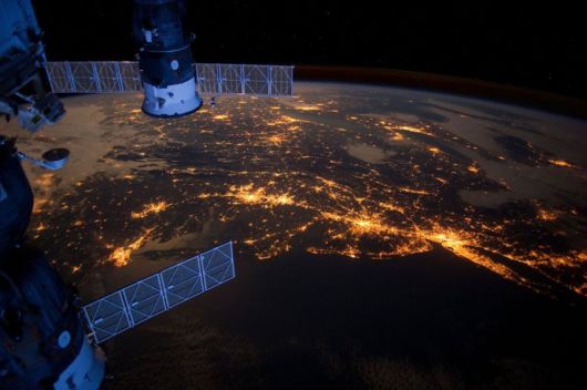
3. Eastern Seaboard at Night An Expedition 30 crew member aboard the International Space Station took this nighttime photograph of much of the Atlantic coast of the United States. Large metropolitan areas and other easily recognizable sites from the Virginia/Maryland/Washington, D.C. area are visible in the image that spans almost to Rhode Island. Boston is just out of frame at right. Long Island and the New York City area are visible in the lower right quadrant. Philadelphia and Pittsburgh are near the center. Parts of two Russian vehicles parked at the orbital outpost are seen in left foreground. An Expedition 30 crew member aboard the International Space Station took this nighttime photograph of much of the Atlantic coast of the United States. Large metropolitan areas and other easily recognizable sites from the Virginia/Maryland/Washington, D.C. area are visible in the image that spans almost to Rhode Island. Boston is just out of frame at right. Long Island and the New York City area are visible in the lower right quadrant. Philadelphia and Pittsburgh are near the center. Parts of two Russian vehicles parked at the orbital outpost are seen in left foreground.
|
|
|
|
|
|
imran
|
 |
« Reply #3 on: December 22, 2015, 05:35:13 AM » |
|
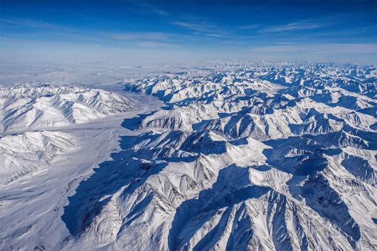
4. Alaska’s Brooks Range Mountains in Alaska’s Brooks Range seen during the IceBridge survey flight from Thule, Greenland to Fairbanks, Alaska. Mountains in Alaska’s Brooks Range seen during the IceBridge survey flight from Thule, Greenland to Fairbanks, Alaska.
|
|
|
|
|
|
imran
|
 |
« Reply #4 on: December 22, 2015, 05:35:37 AM » |
|
5. Rub’ al Khali, Arabia The Rub’ al Khali is one of the largest sand deserts in the world, encompassing most of the southern third of the Arabian Peninsula. It includes parts of Oman, the United Arab Emirates and Yemen. The desert covers an area larger than France. Largely unexplored until recently, the first documented journeys made by Westerners were those of Bertram Thomas in 1931 and St. John Philby in 1932. This image was acquired on Dec. 2, 2005 by the Advanced Spaceborne Thermal Emission and Reflection Radiometer, or ASTER, aboard NASA’s Terra Earth-orbiting satellite. The Rub’ al Khali is one of the largest sand deserts in the world, encompassing most of the southern third of the Arabian Peninsula. It includes parts of Oman, the United Arab Emirates and Yemen. The desert covers an area larger than France. Largely unexplored until recently, the first documented journeys made by Westerners were those of Bertram Thomas in 1931 and St. John Philby in 1932. This image was acquired on Dec. 2, 2005 by the Advanced Spaceborne Thermal Emission and Reflection Radiometer, or ASTER, aboard NASA’s Terra Earth-orbiting satellite.
|
|
|
|
|
|
imran
|
 |
« Reply #5 on: December 22, 2015, 05:36:17 AM » |
|
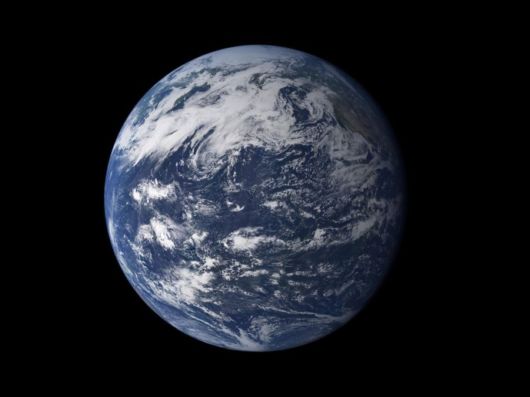
6. The Water Planet Viewed from space, the most striking feature of our planet is the water. In both liquid and frozen form, it covers 75% of the Earth’s surface. It fills the sky with clouds. Water is practically everywhere on Earth, from inside the planet’s rocky crust to inside the cells of the human body.Go to The NEXT Page for More Pictures >>> Viewed from space, the most striking feature of our planet is the water. In both liquid and frozen form, it covers 75% of the Earth’s surface. It fills the sky with clouds. Water is practically everywhere on Earth, from inside the planet’s rocky crust to inside the cells of the human body.Go to The NEXT Page for More Pictures >>>
|
|
|
|
|
|
 IMAGE CORNER
 Wallpapers/Cool Images
 Technology
 26 Jaw-Dropping Images Of Our Planet By NASA
 IMAGE CORNER
 Wallpapers/Cool Images
 Technology
 26 Jaw-Dropping Images Of Our Planet By NASA
